
OK so in Massachusetts recently, technically a year ago but it’s been a slow roll-out, they passed “An Act Enabling Partnerships for Growth” which was signed into law by the governor in January 2021 and added a new section to the Zoning Act called Section 3A of M.G.L. c. 40A. People have been calling this the “MBTA Community Act” because it defines communities within the Massachusetts Bay Transit Authority’s service area as “MBTA Communities” and mandates changes to their zoning laws in order to continue receiving all sorts of state funding programs like MassWorks which is how most major roads gets repaired. Essentially, it’s a law to force suburbs to allow the construction of multifamily housing.
Specifically, Section 3A of the Zoning Act now requires that if you receive MBTA services you are now required to have at least one zoning district in your municipality which allows the construction of multi-family zoning by-right and meets the following requirements:
- Minimum gross density of 15 housing units per acre
- Not more than ½ miles from a commuter rail station, subway station, ferry terminal or bus station, if applicable.
- No age restrictions
- Suitable for families with children.
If you have land within a half mile of a T station (any of the rail lines named after colors, whether light rail like the green line or proper subway like the red line) then that district must be zoned to allow a 25% increase in housing stock. If you get buses, you must allow at least 20% increase, and if you get commuter rail you must allow at least a 10% increase. If you are adjacent to a town with a commuter rail line or subway line but don’t have any stations yourself, you must still at the bare minimum zone to allow 750 new housing units in your town.
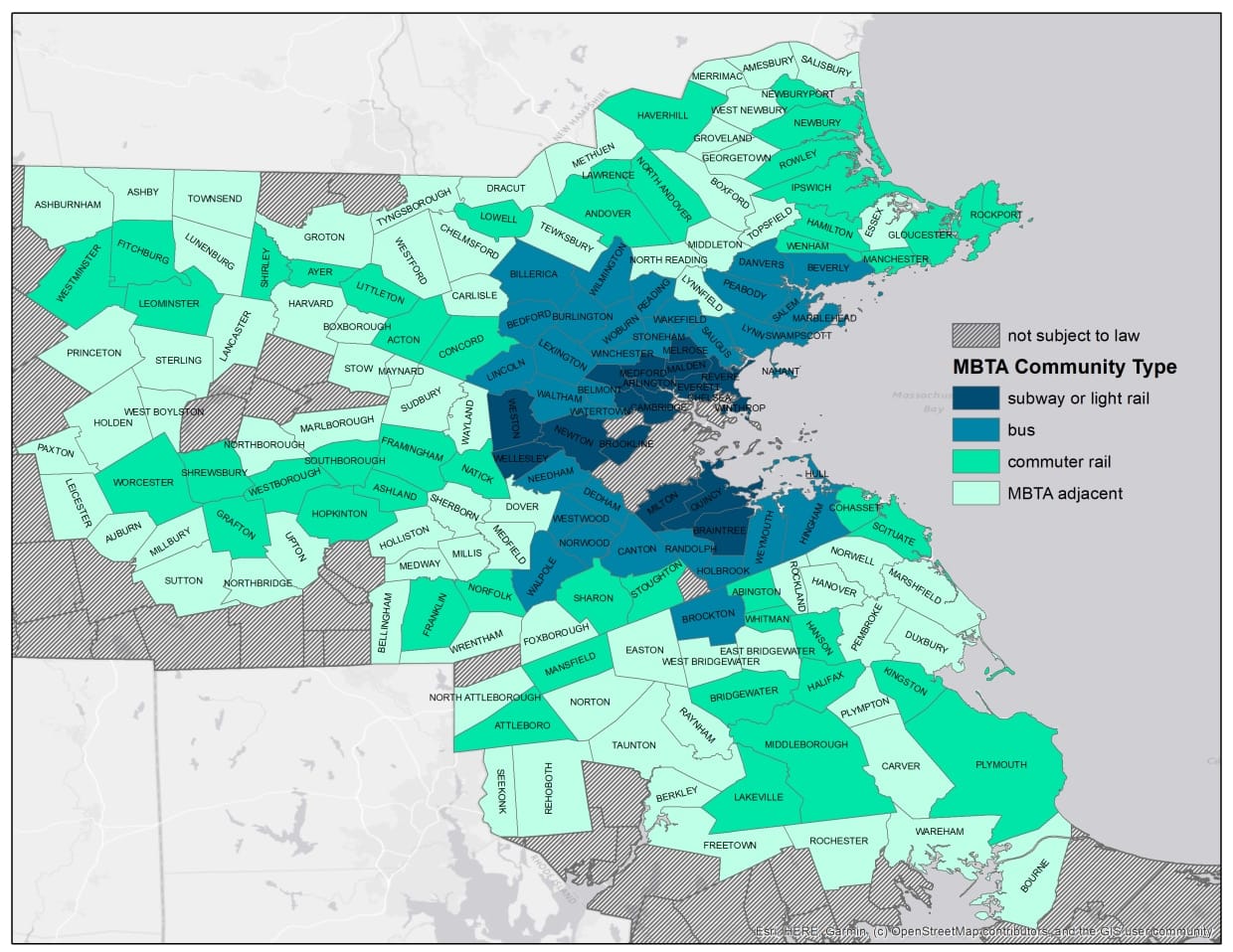
So here’s a map of affected municipalities.

As you can imagine, this is causing absolute fucking insanity among the Boston suburbs who are being mandated to, shockingly, allow new families into their communities. The law does not require them to build housing or even to make it easy to build housing but they must create a zoning district that allows developers to legally build multifamily housing by right at a minimum level of density such that, if a developer wants to build new housing in their town, such that they’d see a 25% increase in housing units, there must be a place where they can legally do it. Transit-oriented development must be legal in every city and town that has transit connected to Boston’s MSA. And it’s happening in nearly half of the entire state.
The background here is that Boston’s CSA is estimated to have a housing shortage of 200k family-sized units, which has caused a housing crisis. They estimate that 350k new units can be added to the CSA by forcing the suburbs to actually accept new residents instead of trying to make 200k more housing units fit in Boston-Cambridge-Somerville alone.
Let’s talk about Weston
The case studies are so exciting and fascinating and cool and also fill you with schadenfreude. Take the town of Weston. Weston has bragged for a long time about having the “best schools in the country.” It has also been among the whitest, richest, and most exclusive suburbs in the entire country. The median household income is over $200k/year. Now… Weston has some land within 1/2 mile of Riverside Station on the Green Line, and currently has 4000 housing units. So their new zoning district, in order to be Section 3A compliant, must allow for at least 1000 new housing units to be developed. And so to meet that minimum, their district must be at least 66.66 acres. The density of these acres could be kept at a minimum by allowing for either rowhomes or clustered “manor homes” which look like big mansions but are actually like six units each. The Town of Weston is 17 square miles, so they have plenty of room, but the district must be within 1/2 mile of Riverside Station. So…. Where can the district be?
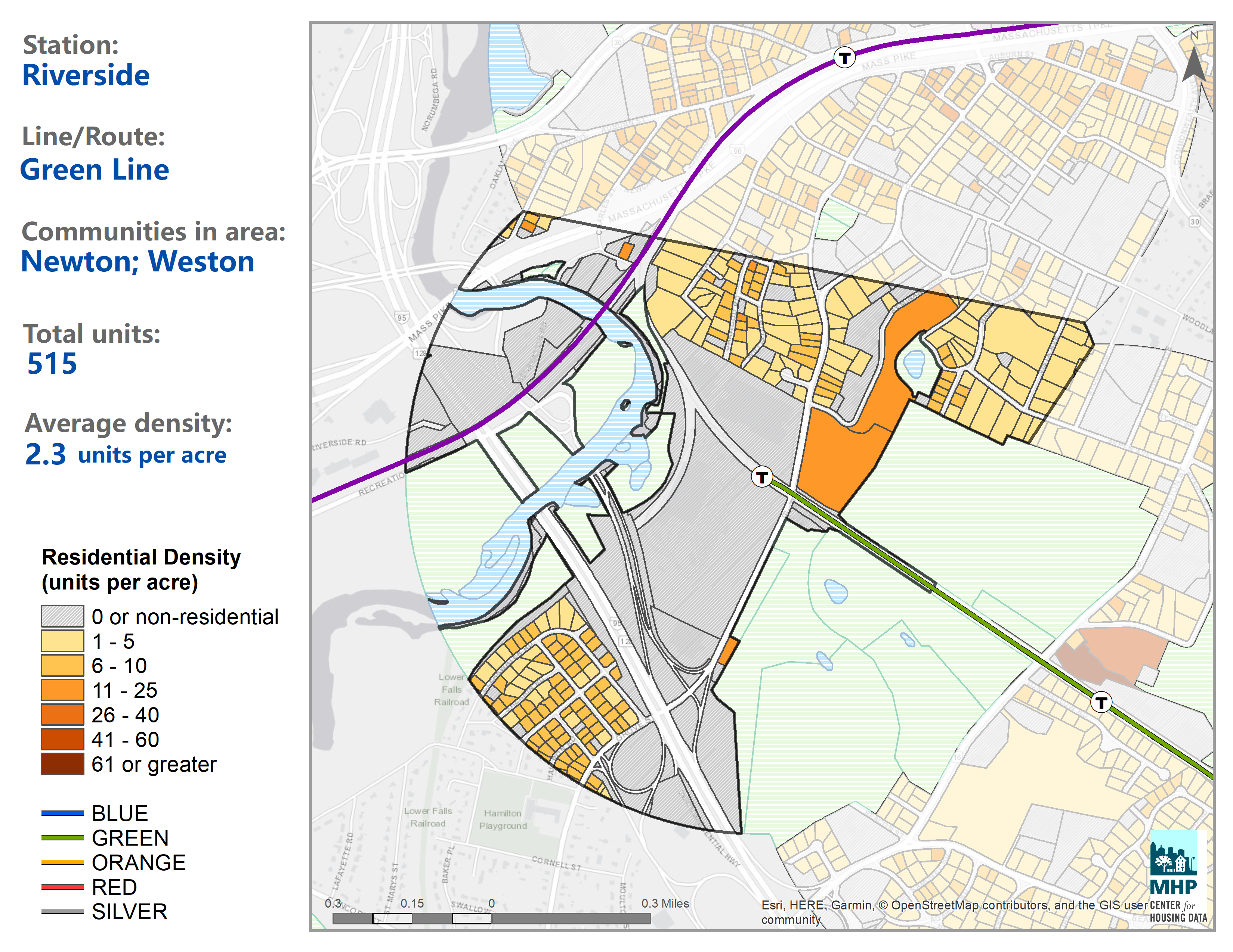
This image btw comes from the incredibly cool Transit Oriented Development Explorer tool, aka TODEX from the Massachusetts Housing Project. We will be using it a lot.
That river is the Charles River. East of the Charles River on this map is the City of Newton, who we will get to in a moment. West of the river is Weston (which is where the name comes from.) You’ll notice there’s not a ton of land there. But that’s where legally they must zone for new housing. Let’s look closer at it and see what’s there.
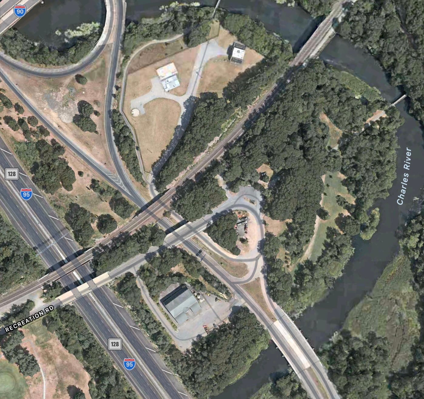
Okay, well, it’s this nub surrounded by highways easy to just separate them out from the rest of Weston and bam you got your housing BUT this area is only thirty acres. Remember, if Weston wants to maintain minimal density, they need to zone 66 acres in order to meet the 15 housing units per acre minimum. So either they must zone this area for forty units per acre; which would require zoning to allow for (gasp) full-fixed medium-rise apartment complexes. The whole thirty acres would need to have about six complexes the size of “The Nash in Texas”.
And all 1000 of these families would be sending their kids to Weston’s schools. The “best schools in the country” that nobody was allowed to send their kids to except the richest of the rich. 1000 new families moving into the community. The State government is saying OK fuckers it’s time to open up and welcome in some new people who need housing.
Now, they could avoid this and still maintain medium density… but only…. if they fuck up the massive golf course adjacent to this district >:3 DO YOU SEE IT. DO YOU SEE WHAT’S HAPPENING.
OK Let’s talk about fucking Newton now
So, full disclosure. I was born in Newton. Newton is another super wealthy Boston suburb, adjacent to Weston. Also known for good schools and having a fuck ton of Jewish people. It’s quite a big city actually, with about 89,000 people in 33,320 housing units. The Boston MSA is actually, according to the Census Bureau, the Boston-Cambridge-Newton MSA. Now, despite this, it’s extremely low density. It’s 90% single-family zoning. One of the most formative parts of my life is that my family lived in a very small apartment in Newton and I didn’t know anybody else who lived in an apartment except for our immediate neighbors in the same complex. All of the kids would be like “you don’t live in a house?” “what’s a landlord?” “you don’t own your house?” “what do you mean you have downstairs neighbors?” and they all had huge fucking houses like so big. We were definitely branded as “the poors” by the other families. So I get a particular satisfaction from knowing that Newton, more than any other suburb, is going to be pushed to actually allow the construction of more apartments and allow a 25% increase in housing, 8000+ new families in fucking apartments. Like it’s normal.
33,320 housing unites, means they have to zone to allow for 8,330 new housing units. Newton’s zoning code currently makes it nearly impossible to build apartment complexes, as they are required to use no more than 30% of their land, with 70% being open space; and can’t be taller than 2.5 stories. At 15 units per acre, to avoid building apartment complexes and just sticking with rowhomes or the like, they would need to create a district that is 555 acres.
It’s worth noting, Newton has seven T stations on the Green Line and three commuter rail stations. Let’s look at some of those stations.
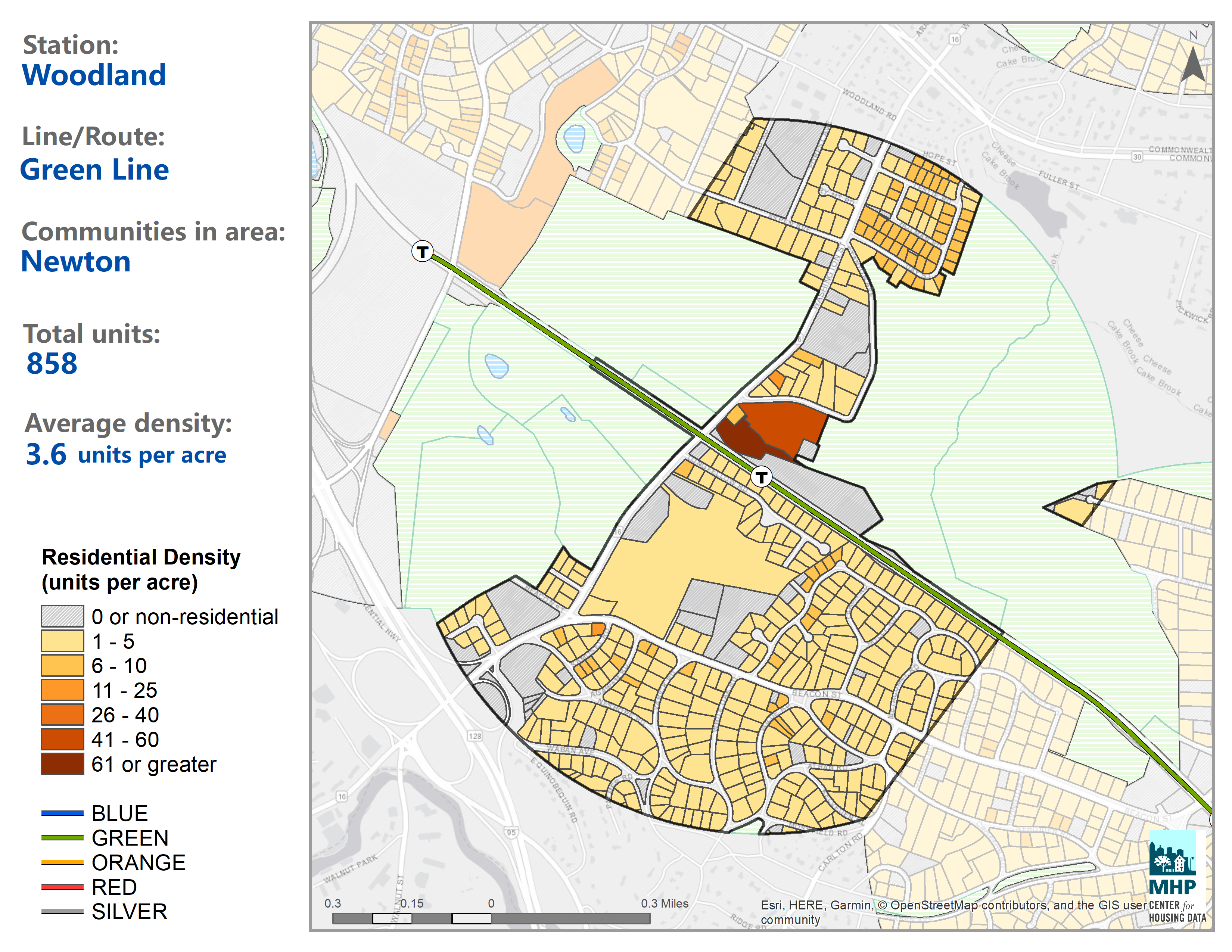
This is Woodland Station on the D line. It’s between the Woodland Golf Course to the West and the Brae Burn Country Club to the east (Yes, furries, that is actually the name of the country club.). Right next to the station is the Newton–Wellesley Hospital to the south, and there is one, singular apartment complex at a density of 40 units per acre next to the station. the rest of the station’s walk-shed (1/2 mile radius, not counting areas closer to another station) is single-family zoning. This station mostly serve two golf courses and about 3 housing units per acre. It only serves 858 people. This is a high-frequency high-speed light rail station in the tenth largest metropolitan statistical area in the entire county. It gets worse though.
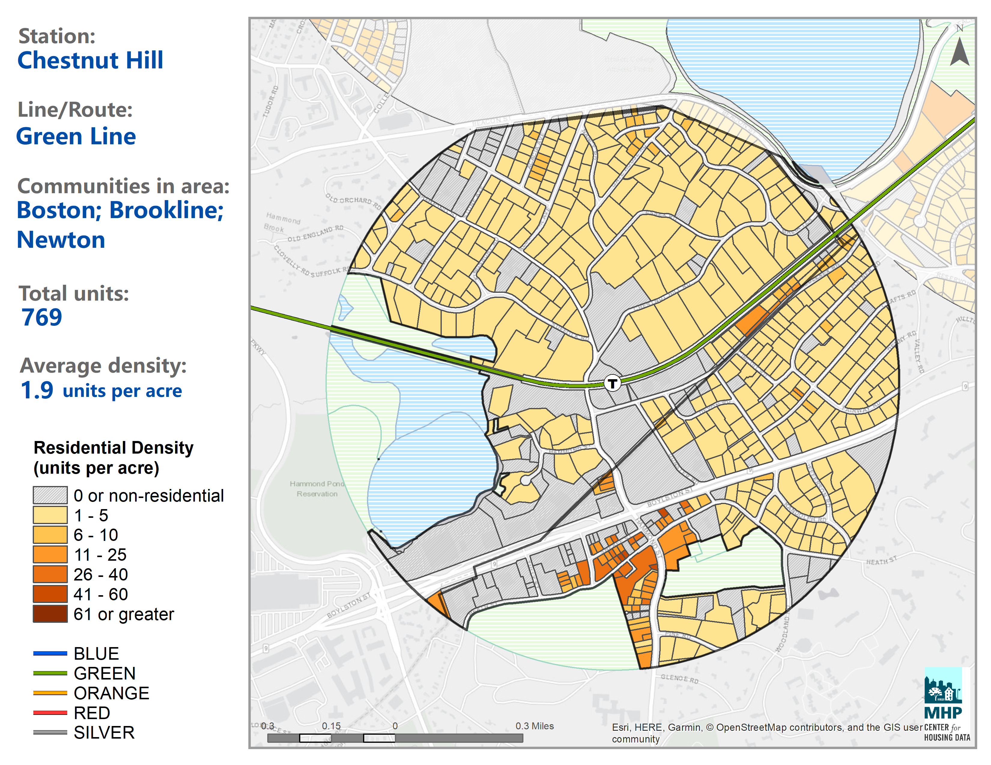
This is Chestnut Hill Station. In the “Chestnut Hill Historic District.” The housing density here is only 1.9 units per acre and there’s not much else here of note either besides the Hammond Pond Reservation and a cemetery. 769 homes are served here.
In fact, the densest D line station in Newton is Eliot Station.
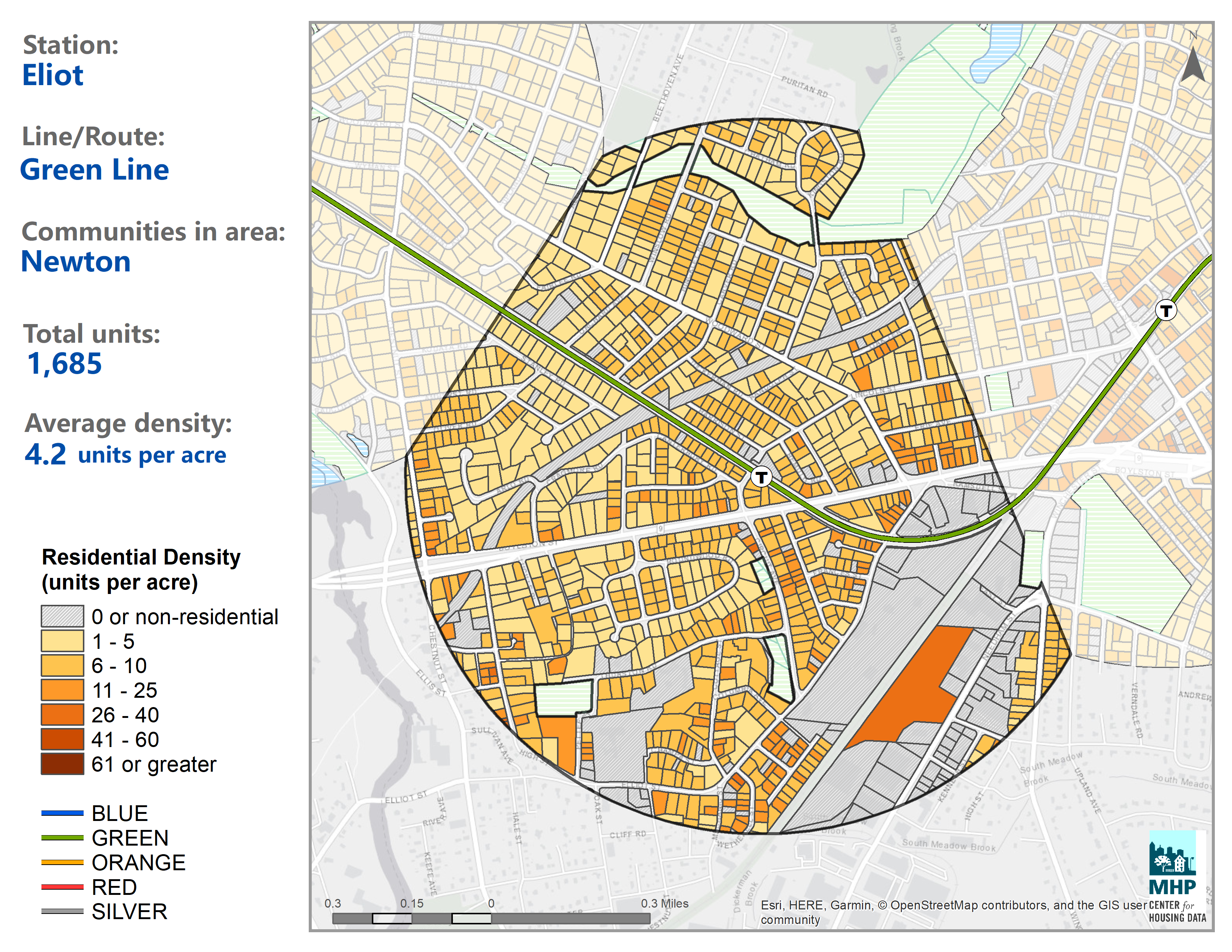
It’s get a density of 4.2 units per acre and serves a little over 1000 homes. You’ll notice it’s still almost entirely single-family homes they’re just a little closer together than other parts of Newton and there isn’t a fucking golf course or country club. Of the seven Green Line stations in Newton, five of them serve a golf course or country club.
The densest MBTA station in Newton is actually Newtonville station on the commuter rail, with 5 units per acre. But the commuter rail only serves this station once an hour outside of peak hours. The D line is rapid transit. It should be serving more people.
Remember, the absolute minimum zoning for this MBTA Communities Act is 15 units per acre. Even the densest part of Newton is only one third of what it needs to be. And 15 units per acre is only some townhomes or 6-unit-each manor homes that look like McMansions anyway.
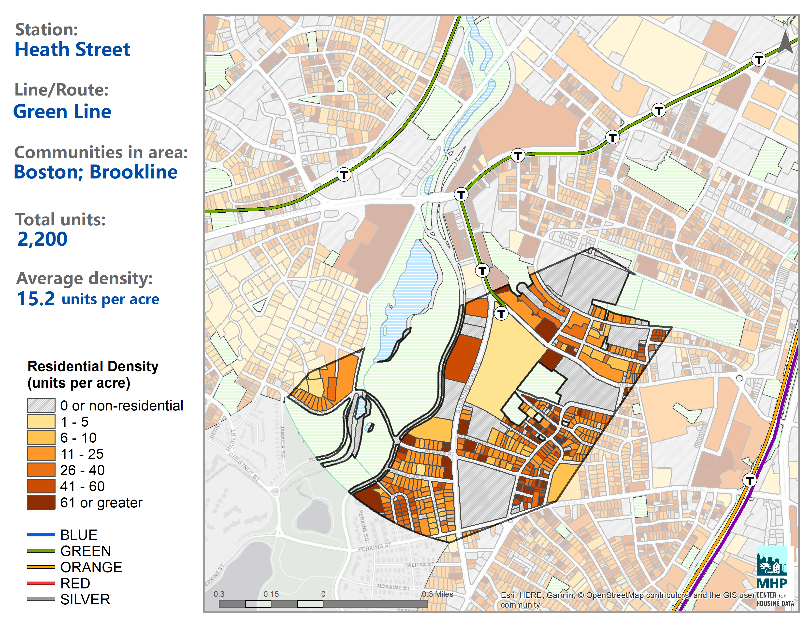
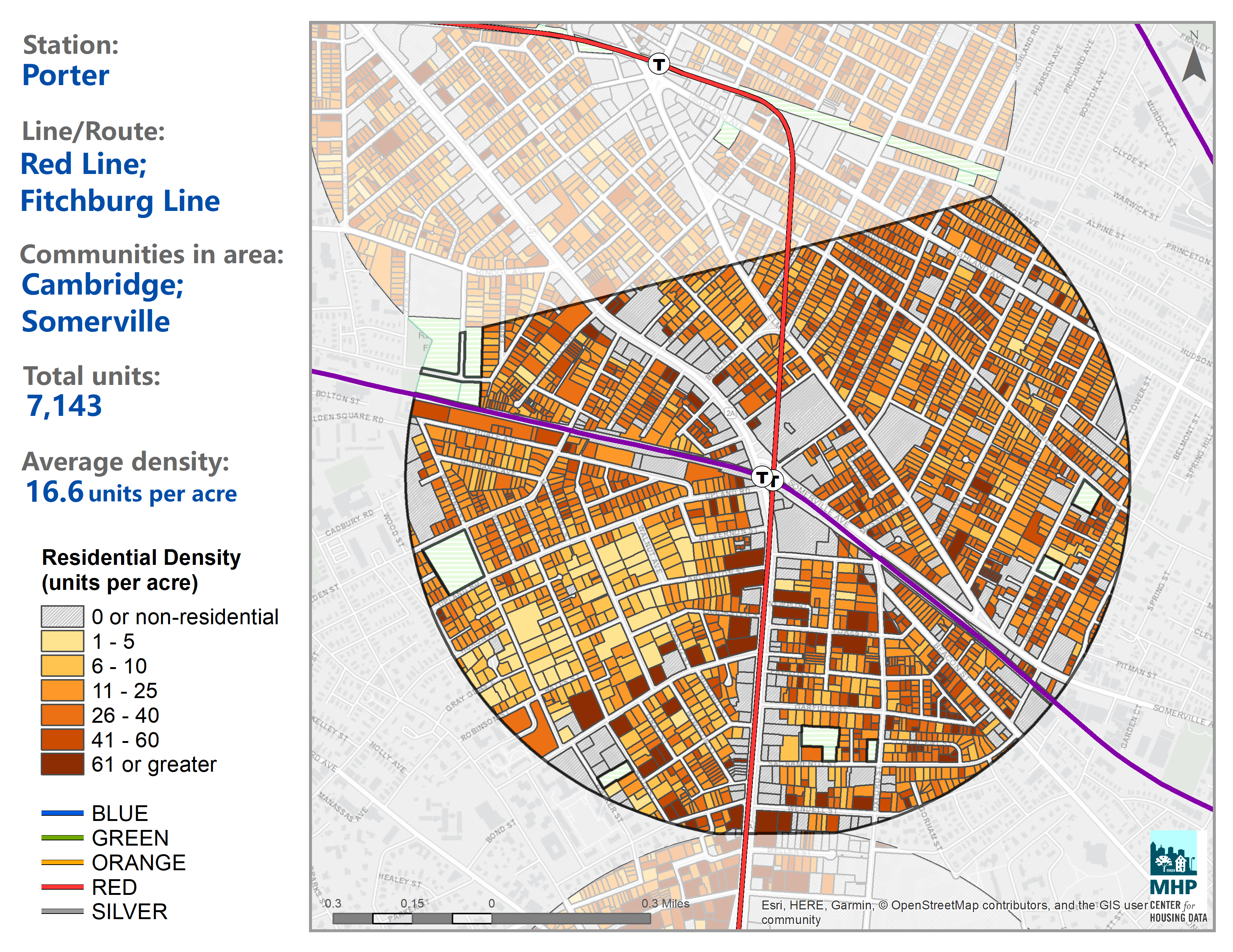
By comparison, here’s three stations which meet the absolute minimum density for the MBTA communities act.
Heath Street in Boston, of note is this is also on the Green Line and adjacent to a large green area (except it’s a beautiful public park with a pond and not a golf course). Housing here is a mix of small apartment complexes, mixed-use, and duplex homes.
Porter Square Station, off the red line subway in Cambridge and Somerville. Housing here is mostly triple-deckers, three apartments stacked on top of each other. They look like single-family houses but house 3 families instead. There’s a few small apartment buildings and some mixed use development.
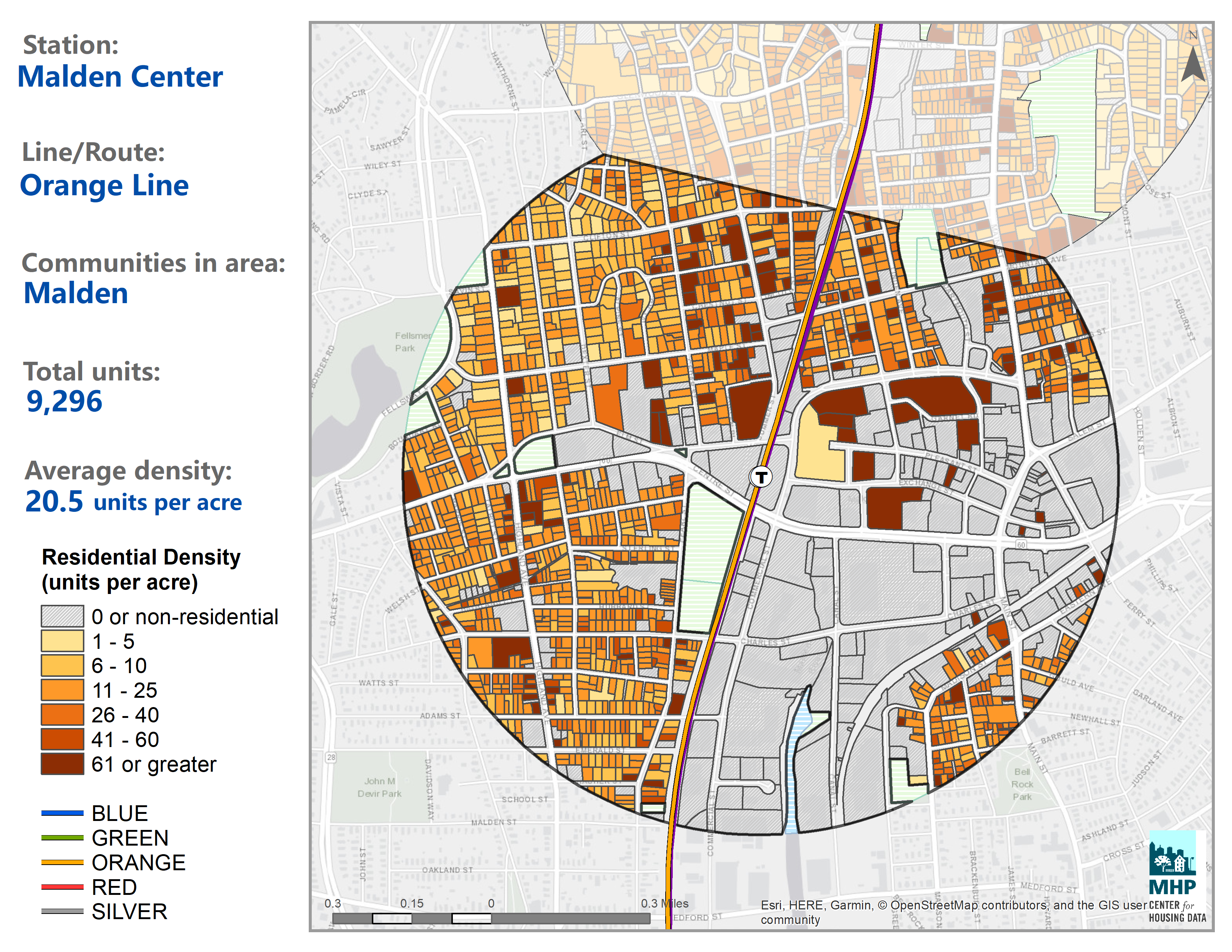
And Malden Center Station, off the orange line subway in Malden. Malden is a suburb of Boston with a population of 66,000 people. Housing here is predominantly single-family homes, mixed-used development (apartments over shops), and apartment complexes. This is actually the second most densely populated T station walk-shed which surprised me since Malden is so suburban and predominantly car-dependent outside of Malden Center which is quite small. I think the data is partly skewed because stations which are closer together in the City of Boston have smaller TODEX areas since they only count the land nearest to them and not to another station.
Remember, the law isn’t that every station needs to be as dense as these three. Just that at least one of them be allowed to become as dense as these. There’s 320 acres in a half-mile walkshed. Newton needs to zone 555 acres at 15 units per acre to be compliant, or fewer acres at higher densities. All the City of Newton has to do is allow large apartment complexes within a half-mile around one of their seven green line stations and they’ll be compliant; or allow triple-deckers and townhomes around two stations. They could also give up a single golf course and zone it all for medium-density housing and that would easily get them to meet the minimum for compliance.
So what’s the government of Newton talking about doing?
Newton City Council is Basically Arrested Development
So here is all the funding Newton has received from the state which they would no longer be eligible for if they refuse to be compliant with the new law. This whole section comes from an article on Patch
- $7 million in Massworks funding for Route 9 improvements (2012-2014)
- $1.6 million in Massworks funding for Oak Street/Needham Street Intersection (2019)
- $400,000 in Masswork funding for design of Pettee Square (2021)
- $220,000 in Housing Choice funding to undertake affordable housing feasibility study for West Newton Armory
- $75,000 in Housing Choice funding to examine zoning options for California Street manufacturing area
Here’s how the debate in Newton City Council has been going.
Councilor Marc Laredo spoke out against the state constructs, saying he would rather the city choose to create more multi-families units themselves without being pressured to do so.
"My view is that the state constructs create significant issues for us in limiting our ability to manage and control what gets built here," he said. "And I think we need to weigh that against what in my mind is a very small amount of funding at stake."
Some quick math on you, this “very small amount of funding at stake” is $9.3 million dollars over the past ten years.
So what about the other side of the debate? The pro-housing camp?
"What we don't want to do is embarrass ourselves by essentially saying that we're wealthy enough to walk away from this and without complying," said Councilor Vicky Danberg at a Jan. 24 meeting. "It's kind of like parking in a handicap parking place because you can afford the fine."
It’s one parking ticket, Michael, what could it cost? $9.3 million dollars?
I mean really, wouldn’t it just be so embarrassing to be the only city in Greater Boston who didn’t comply with the Zoning Act? What would Brookline think of us? Oh could you imagine what they’d say about us in Waltham. And I’m not letting those ruffians in Arlington look better than us.
Nevermind that Newton is the fourth biggest city in the core of Greater Boston (after Boston, Cambridge, and Quincy) and is full of land that is being used for nothing but golf along the fucking subway system. And there is a housing crisis and the region needs 200,000 units of housing yesterday just to break even let alone prepare for continued growth.
In Conclusion
It’s really fucking rad that this law is forcing suburbs to welcome in new families and allow multifamily housing and transit oriented development. It’s a huge deal and some of these suburbs haven’t built any new housing at all in decades (looking at you, Wellesley, where it’s basically illegal to build any house).
Growing up in Newton and being very familiar with all of these suburbs, I can very vividly imagine so many places where transit oriented development could go that would be really healthy for the region, provide high quality schools to families who have been locked out because none of these communities will share their money with the City of Boston’s public schools, and oh my gd there’s just so many fucking golf courses that could be redeveloped and it’s very satisfying watching these suburban governments panic about having to let there be fucking apartments. More families like mine being able to afford to live along the damn green line instead of getting priced out and having to move to the car-dependent MetroWest region because moving further into the city sure doesn’t get any cheaper either when you’re a family of four and developers love to never build apartments with more than two bedrooms.
Though that’s only if these rich suburbs are willing to actually do it instead of deciding to give up millions of dollars. Because, after all, they could just raise local property taxes, further pricing out any outsiders and making up for state funding themselves. Truly it would be embarrassing. I think they could also just make it technically legal to build the required minimum density but just make it very difficult and expensive with things like parking minimums; but honestly what developer wouldn’t jump through any hoops to build 1000 condos in “the town with the best schools in the country” y’know? It would be a real challenge to keep them out once it’s legal.
Anyway, I think the City of Boston should be allowed to annex Brookline and Newton and convert all of the golf courses into transit oriented development. That Brookline gets to be its own city and keep all of its money internally and not share is just so ridiculous I mean look at the map.
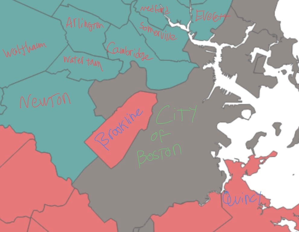
Brookline isn’t even the same county as any of its neighbors. Why is it an island like that. Brookline and Newton are just begging to be annexed when you have borders like that. Everything within the boundaries of the Charles River should be the City of Boston. I mean I have a lot of various options for many city-town consolidations for the region but this one just feels the most obvious. Second most obvious is Somerville should annex the parts of Medford south of the mystic river.
Anyway that’s my extremely autistic geeking out about statewide zoning ordinances in a state I don’t even live in anymore.