
I like looking at transit maps for fun and of course how transit systems are designed often is a part of soft-segregation by making it difficult for people to go to places where they "aren't supposed to be"
The two cities I'm most familiar with are Boston and Philadelphia, and they seem to take two different approaches to this. I think Boston's is far more egregious.
Differences in structure
Philadelphia's geography
Philadelphia's Center City was one of the world's first planned cities, planned by William Penn from whom Pennsylvania takes its namesake. In 1854, every single city and town in Philadelphia County was consolidated into the City of Philadelphia (which is also still the County of Philadelphia).
So Philadelphia is a grid-based city. Vertical streets are numbers 1 through 70-whatever going from east to west; and horizontal streets are named after trees ordered by the density of their wood going from south to north. This naming scheme kinda falls apart in a lot of places when they add streets or leave William Penn's original grid but whatever. It's a grid based city that's very oriented around cardinal directions. City Hall is in the middle, and the entire city is generally just carved into vague cardinal descriptions like West, Southwest, Northwest, Northeast, Upper Northeast, North, Upper North, Center, South, and Deep South. Places within these clusters might have neighborhood descriptions like "Chestnut Hill" or "Cobbs Creek" but people don't generally get that specific outside of the cluster they live in. If you live in Northwest, the difference between Chestnut Hill, Roxborough, Germantown, and Mt. Airy is meaningful to you, but everyone else will just called it "Northwest."
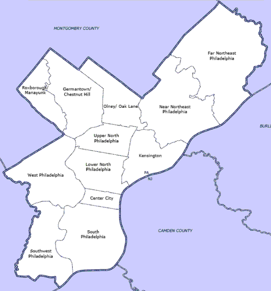
The economy is very centralized in Center City; with UPenn and Temple University serving as dominating institutions in West and North Philly respectively; but besides the universities nearly every major employer is in Center City. Furthermore, most of the major economic and residential areas are within city limits; the lines between city and suburb are very clear and the suburbs are far less populated and less developed. Very few people "reverse commute" in Philadelphia.
Boston's Geography
Boston was the first major metropolis founded by English colonists in North America; created by some of the first settlers. It was, in absolutely no way, planned. Many tiny colonies popped up all over the area and as they grew their borders collided and formed a very decentralized metropolis. Unlike Philadelphia, there was never a county-city consolidation for Boston, and in fact, the metropolis spans several different counties with completely nonsensical borders. Several nearby colonies were annexed into the City of Boston, but they did so one at a time by local town-meeting votes. The result is that most of the metropolis is not the City of Boston at all, including the majority of major employers, and which parts are and aren't are kinda arbitrary geographically. Even locals who grew up in the area (like me) struggle to keep track of what is Boston Proper ("Rozzie is Boston Proper?") and what isn't ("Brookline is its own city?"). (I don't struggle with this anymore because I have a special interest in maps. But I doubt like, my dad, who has spent his entire life in the area, could tell you that Somerville is its own municipality and Charlestown isn't.)
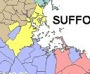
This is irrelevant to bus networks but Seriously, wtf is Norfolk County (blue) even doing. To make things weirder, counties in Massachusetts don't actually have any governing responsibilities besides determining which court you go to for jury duty; but they're still used for statistical purposes for some stupid reason. So if you're looking at COVID numbers for "Suffolk County" it's excluding Brookline (the blue blob being surrounded by the yellow) because Brookline is technically Norfolk County.
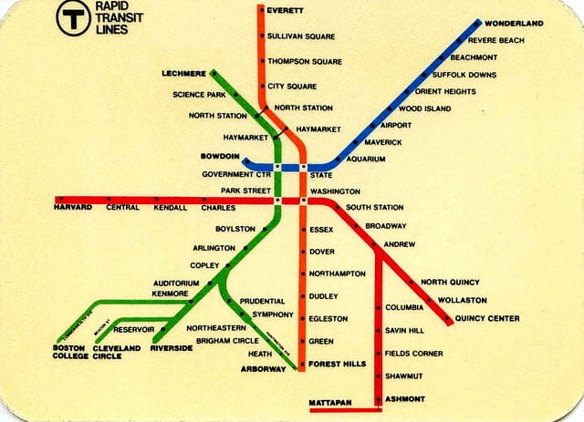
The resulting metropolitan layout, where different local governments seem to determine what to do with every 4 square miles of land, is commonly described as "a spaghetti mess" but is more politely described as a decentralized "streets and squares system." The metropolis is many decentralized economic centers, or "squares" which are connected by major avenues/streets that simply go directly from one square to the next with no concern for angle. Typically, the major square are centered around a T station, sometimes because they placed T stops in major squares and sometimes because a square grew due to there being a T stop placed there. (the T is the transit network, usually the subway trains, but also is sometimes used to refer to the buses, light rail, etc. so yes actually sometimes Boston locals do say "the subway" if we're differentiating it from, say, the bus. Take that, Mia from Connecticut who got on my case and called me a fake local because I didn't say "the T" instead of "subway" one time.)
This decentralized system means there's a lot of "reverse commuting" where people who live inside the urban core actually take the T out of Boston Proper and into surrounding communities, including the suburbs. Defining "suburb" in Boston becomes difficult. Even if a city like Newton is mostly rich people in single-family homes; people who live further into the urban core take the T out to Newton every day to work at institutions like Brandeis University.
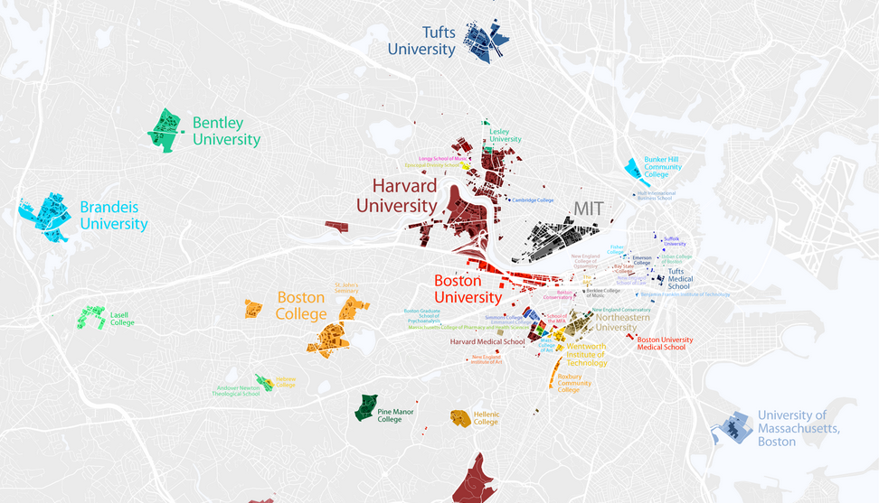
In addition to all these universities, there's all sorts of private pharmaceutical companies and biomedical research firms all over the place, especially in Cambridge near Harvard and MIT; but you'll also find them (and Google) way out in Framingham which isn't even on this map. Legit, people are going all over in this place and most of it ""isn't Boston"" (but it is).
OK so the bus networks
All that infodumping about city-layouts out of the way, let's talk about bus networks. Transit determines where you can go, if you're of a certain income level or less. People with cars tend to be wealthier and they can go wherever they please. People of all income levels take transit, but lower-income people can only take transit. Furthermore, rails versus tires are racialized. White people, infamously, are happy to ride trains and trolleys, anything on rails, but will avoid riding the bus. Buses are seen as inferior, dirty, even dangerous. Now, a trolley is legitimately more cost efficient, faster, environmentally friendlier, and easier to maintain than a bus; but they're also harder to detour for construction, and have a more steep up-front cost when it comes to creating or upgrading a trolley line. If you have a major thoroughfare, rail will be worth it; but for less-trodden paths usually it just makes more sense to run a bus.
The end-result, however, is white people are usually happy to live in neighborhoods served by a rail line, but will avoid neighborhoods only served by the bus, or if they do live there, will buy a car if they can and avoid the bus. Even white workers who work from home and don't commute via subway at all, often find it more desirable to live near a rail station than a bus station, you know, just in case they want to leave Upper Manhattan today to like, go to a restaurant.
Knowing this, if you're trying to control where people go, to keep certain people in certain locations and not other locations, which is to say, to segregate neighborhoods without officially segregating them, the bus network is a strong way to do that. You can literally prevent people in a Black neighborhood from getting to a white neighborhood by just not connecting them via bus. Only the people in that neighborhood wealthy enough to afford a car will be able to get between them, that or they can make a whole bunch of transfers and take like 2+ hours to get there and that's usually just not worth it.
Philadelphia's bus network
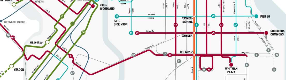
Philadelphia has a grid-based bus network, mostly. Which is great!! In theory, this circumvents segregation by making taking the bus about as easy driving the car in a straight line.
Philadelphia is a "majority minority city" which means no single racial group comprises >50% of the population. Black people make up the plurality of the population, meaning they have the largest slice of the pie, but it's still <50%. In some parts of the city, such as West Philadelphia and Southwest Philadelphia, Black people make up 70 to 95% of the population. In other parts of the city, like Northwest and Upper Northeast, they comprise a much smaller slice of the pie.
Now, looking at this map, you'd think that the buses are not pushing segregation. Look: you can even take the G bus directly from predominantly Black Southwest into predominantly white "Deep South Philly".
However, "deep south Philly" is not a wealthy neighborhood, it's just an Italian neighborhood. Maybe middle class, but not wealthy. The wealthy white parts of Philly, excluding old-monied Rittenhouse which is also a major shopping destination, are Northwest, specifically Chestnut Hill and Mt. Air; and Upper Northeast. Infamously, city employees like police officers will move to these neighborhoods to get as far out of the city as they can while still technically living within city limits.
What happens to bus service when we look at these neighborhoods?
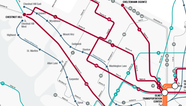
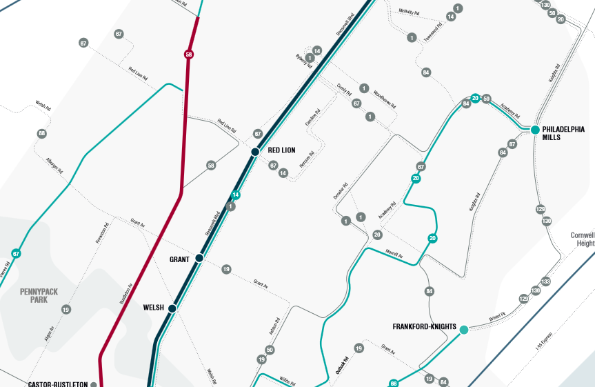
Well, Philly makes it hard to get to these neighborhoods by just not giving them buses. While Northwest does have like, the one or two buses you can take to get to the subway, the neighborhoods overall are not navigable by transit so it's pretty car dependent. There's no north-south buses, they shoot straight diagonal to the subway. If you wanted to get here from West Philadelphia you'd have to take the bus to the El to the Subway to another bus then ride it to its terminus. It takes 90-120 minutes for what would otherwise be maybe a half an hour drive. Northeast Philly is even worse. There's hardly any frequent bus service at all. Even if you get into the macro-level region... you're certainly not getting to many houses. You'd have to get a ride from the bus to wherever you're going. Cars are necessary here. I used to regularly head out to Tacony from West Philly for a kink meet-up and doing it via the rapid transit was impossible. I had to drive or take the Regional Rail Line from the station new UPenn.
So the way Philadelphia segregates using its bus network is somewhat unsubtle. The buses just, don't go to the neighborhoods that don't want poor people of color entering them for any reason. But those parts of the city are pretty suburban in feel anyway, sparsely populated, and you don't have a lot of reason to go to them anyway.
Boston's methods are much more nefarious.
Boston's bus network
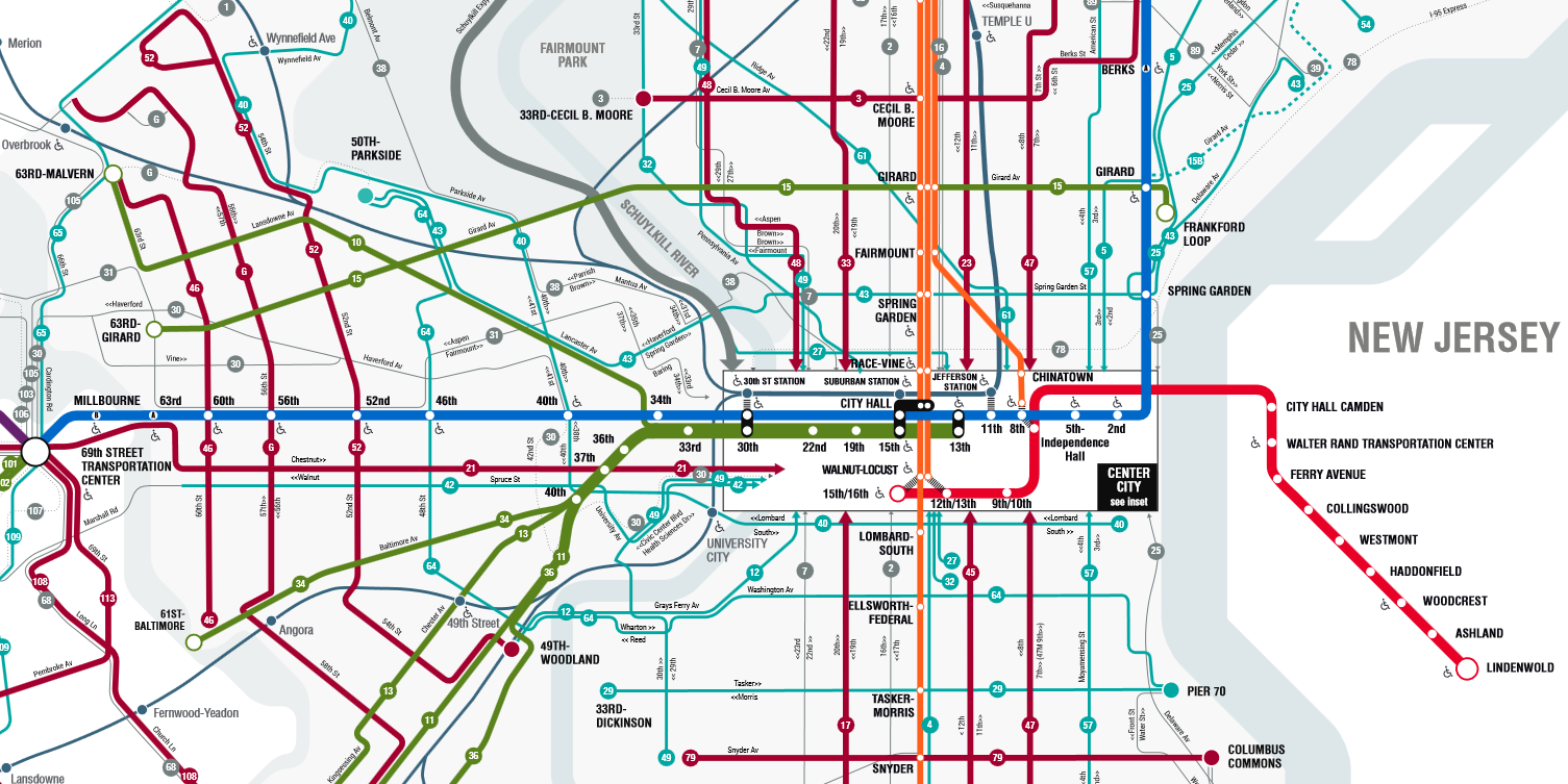
Boston's bus network is absolutely not grid based. The buses instead do follow the "Streets and squares" system. They are not designed to get you from point A to point B. They are designed to get you from Square A to Square B. In-effect, the buses are meant to get you to the nearest T station (in this case I mean the subway), not to your job. They often run directly from one T station to another T station; to catch everyone living slightly out of walking distance from either station.
This system makes a lot of sense given that Boston has a more extensive subway system than Philly, albeit a very centralized one where rail runs to downtown and out again; but not usually radially. Which is unfortunate in such a decentralized city. The buses mostly serve to fill gaps in the T and get you onto rail; or to move you radially between two lines.
However, Boston very infamously rerouted the T so that it doesn't run through poor neighborhoods with Black and Latino communities much.

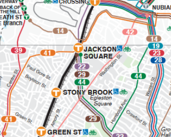
The Orange Line once served predominantly-Latino Everett to the north and predominantly Black Roxbury to the south, take special note of "Dudley" referencing what was once called Dudley Square, the most famous Black neighborhood of Boston, which has since been renamed to Nubian Square in recent years. In the 70s and 80s, the MBTA rerouted the Orange Line as part of submerging it underground and straightening it so it can go faster... supposedly... but what it really did was shift it so that it no longer served Everett or Nubian Square. To the north, it now serves the suburb of Malden, previously a white suburb but now actually a pretty diverse suburb with lots of different immigrant communities. To the south, it now serves Jamaica Plain, a pretty diverse neighborhood today but, at the time, a mostly white neighborhood. (Fun fact: the name "Jamaica Plain" has nothing to do with Jamaica, the island. It comes from an anglicized hearing of a native Massachusett name for the pond it's near.)
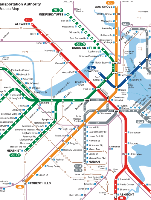
Everett isn't even mentioned on this map, despite being a major economic center with the casino resort area. It's now entirely served by buses. Where the label "SL3" is on this map obscured where the Everett label would be. Everett is quite the urban city, but it only gets buses. The T now goes to Malden, which is a great place, but it's hardly urban. It has a nice downtown area, but is otherwise mostly suburban single-family homes surrounded by woods. It's bizarre that it was prioritized for a subway station. To the south, the T just completely avoids Roxbury ("Roxbury Crossing" is, in fact, the border with Roxbury, not Roxbury itself). Jamaica Plain is pretty urban so subway services makes sense, but maybe building a new line would have been better? Roxbury residents protested this change quite a lot, and the concession they were given was a new line would be added to The T serving Nubian Square. What they got was the Silver Line, which is not a subway line. It's Bus Rapid Transit. Which means it's just... above average bus service. It has a few dedicated lanes and it runs frequently... but it's still a bus. The Black neighborhood lost their rail, and were given a bus to replace it. The MBTA never promised a subway line, just "a new line on The T." and remember, "the T" only usually refers to the subway, not exclusively though.
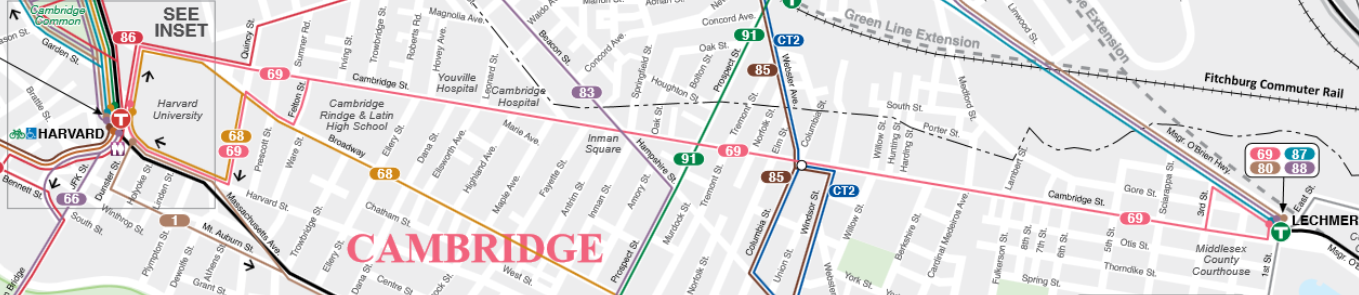
The bus routes are also just weird. Look at Hyde Square, Boston's "Latin Quarter."
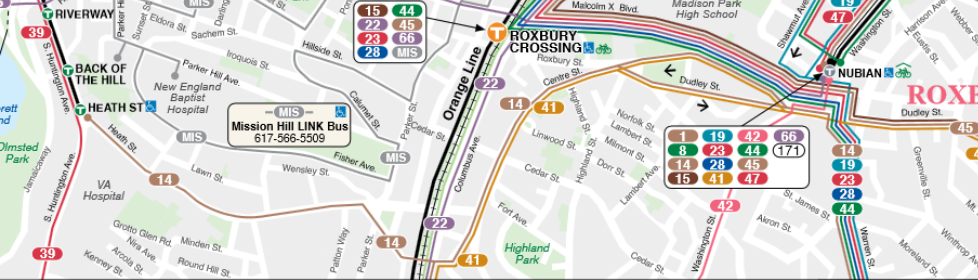
It's hard to see because it's on the border of an inset, but the buses serving Hyde Square really don't want to take you directly to wealthier neighborhoods, or even the rail lines. The 14 bus takes you all the way from Hyde Square to Nubian Square for the silver line, but completely avoid any of the Orange Line stations. It does connect to the E line, but the E line is a trolley without dedicated lanes. It's basically a bus on rails. The E line used to run through Hyde Square but then they shortened it at one point so it stops at Heath Street. The 39 bus will take you up to the E line along where it used to run, and then just, runs parallel to the E line? So if you got on the 39 bus there's no reason to transfer to the E line (which, again, runs in mixed traffic with cars.) The 41 bus connects to the Orange Line, but seems to swerve to avoid Hyde Square, forming a triangle outlining Hyde Square. Why? Huh?
And let's look at Newton, a wealthy white suburb that got its own big fancy light rail line (the D line) but, just, doesn't have any buses connecting the houses to the train?
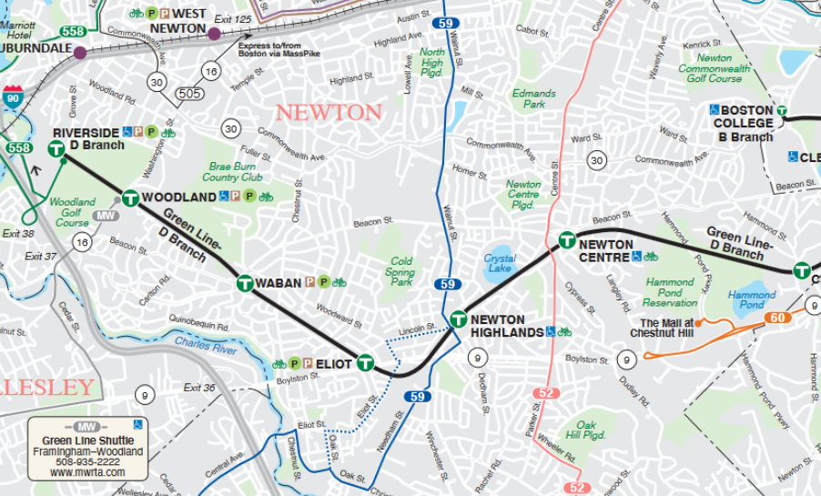
All over the rest of the city the buses are all about getting you to the T stops.... except in Newton which has seven T stations but only three bus lines. Why do Everett and Roxbury get no T stops and Newton gets seven in a community that doesn't even have buses to get them to the train? Well, for one, people in Boston are willing to walk really far distances. A fifteen minute walk to the train station is like, fine for Bostoners. But also, essentially, this means that you can reverse-commute into Newton for the economic centers around these T stations (so that the poors can work at your local Dunkin) but they aren't able to easily get into the actual residential neighborhoods like Newton Centre which are full of McMansions.
The D line is the line I took a lot growing up, but it's just so wild to me that it even exists now. It exists further west than anywhere else along the T to the point that maps have to squish it and distort it to make it fit if they want to stay a square and not zoom out a ridiculous amount. But the city it serves is all people who own cars and drive everywhere. People do take the D line certainly, when I commuted along it it would get quite packed by the time it merged with the other green lines at Kenmore Station, But there's just no bus service to make it easier for people to use it.
Conclusion
Segregation walls never fully went away. Even if there's not a literal wall there, the buses and trains sure do act like those are lines that can't be crossed. Fortunately, both Boston and Philly are currently undergoing major bus network redesign projects led by people who seem to really prioritize equity and serving low income neighborhoods. I'm hoping these fresh young urban designer people will start thinking about how to make networks that make it easy to get from anywhere in the city to anywhere else in the city; rather than designing things to make white people feel safe that people of color can't get into their neighborhoods.